This Month’s Featured Article

Musk’s Satellite Offers Hope for Environment
In an age where AI is rapidly overtaking man’s ability to solve the world’s problems, Elon Musk – the brains behind Tesla, PayPal, X (formerly Twitter), and so many other successful endeavors – is working feverishly to help solve one of mankind’s greatest dilemmas through another of his masterminds, SpaceX. The challenge he’s hoping to help NASA solve: climate change.
On February 8, Musk bankrolled the $948 million launch of NASA’s Plankton, Aerosol, Cloud, ocean Ecosystem satellite mission from the Kennedy Space Center in Cape Canaveral, FL.
With a three-year design life and ten years of propellant, the data collected from PACE is expected to share how carbon dioxide is exchanged between the ocean and the atmosphere. Scientists hope PACE will show how aerosols fuel the growth of phytoplankton in the surface ocean.
The local connection
PhD Kathleen Weathers is a distinguished senior scientist at the Cary Institute of Ecosystem Studies in Millbrook, NY. She’s been affiliated with the Cary ever since she received her master’s degree. Weathers said her roles at the elite environmental research center have “metamorphosed about three times” during her 40-year tenure. She explained the importance of understanding aerosols for the lay people reading this article (as well as for the one writing it), and the critical role aerosols play in global warming: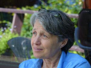
“Aerosols and clouds play very important roles in modulating the energy balance,” she explained. “They can absorb, reflect, or scatter radiation – functionally, they can exacerbate [cause more warming – act as a sweater] or offset [cause more cooling through reflectance – act as an umbrella] global warming. But we do not have good measures of cloud and aerosol cover [spatial extent], and their characteristics [thick, thin, particle size, etc.], and thus we cannot build these very important processes into our models of how the energy balance on earth is changing. As such, one of the biggest sources of uncertainty in climate models is the absence of cloud and aerosol data.”
PACE is expected to reveal key data about phytoplankton. “We can talk more about this but in a phrase: Phytoplankton are life,” said Weathers. “They are photosynthesizing aquatic organisms that take in carbon dioxide and release oxygen. They are like green plants and trees on land. They are the base of the food web in the ocean. It is essential that we understand where they are and what they are doing [sequestering carbon, serving as the base of the food web, etc.] in the ocean. Satellite technology can help us get a picture of where [and who – there are many species] they are.”
That’s exactly what NASA scientists and the global scientific community hope to learn from PACE, according to NASA’s director of Earth Sciences Division Karen St. Germain, cited on pace.oceansciences.org. “Novel uses of PACE data will benefit our economy and society,” she said. “For example, it will help identify the extent and duration of harmful algal blooms. PACE will extend and expand NASA’s long-term observations of our living planet. By doing so, it will take Earth’s pulse in new ways for decades to come.”
A quantum leap forward
Lamont research professor Ajit Subramaniam, an oceanographer at the Lamont Doherty Earth Observatory at Columbia University in New York City, said he was “tremendously” excited when he first learned of the PACE mission. As an ocean researcher, he works directly with the PACE mission.
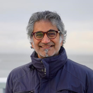 “This is really a quantum leap forward in terms of the information we can get regarding ocean and biology chemistry of oceans,” said Subramaniam, who’s studying the Amazon River. “I do not go up the Amazon; I look at the fresh water coming out of the Amazon into the ocean. I know big river people don’t appreciate fresh water coming out the Amazon.”
Yet he said perhaps they should, as 20% of all freshwater from the word’s rivers comes from the Amazon River, which is 16 times larger than the next largest river. It’s also the length of the main stem of two Mississippi Rivers – Subramaniam said he’s studied the Amazon for so long he could recite such facts into perpetuity.
The Amazon’s freshwater lens, he added, spreads over the Atlantic Ocean and covers an area that’s greater than one million square kilometers. “Think of it as a plume of freshwater,” said Subramaniam. “It’s like a couple of Texases.”
The lens, or plume, is the part of the river that enters the ocean or a body of saltwater, and form a surface layer on it. That layer is known as the lens or plume; it’s roughly 30-feet deep (with freshwater below and a layer of saltwater above).
“I study large rivers of the world in terms of how they affect oceans,” said Subramaniam. “Until now, we only knew how much phytoplankton there was in total. Now we can see who it is, not just how much but who as a species… knowing who it is is really critical,” in terms of the food chain, so scientists can figure out who eats where, as well as any changes in food quality, as plankton changes will affect the water system as much as climate change. “We need to understand these things. PACE is a game changer. We’re all very anxious to get our hands on the data.”
Transparency and free flow of information
According to Subramaniam, PACE is currently in its “shakedown” phase with NASA examining the raw data. The data flow should be shared with the international scientific community within a month or so.
That free flow of information is hugely beneficial, according to Subramaniam, who said NASA’s open-door policy when it comes to accessing data only requires scientists to register. Subramaniam said only once did he encounter an instance when data was held back by a nation, which benefitted no one.
“There’s no gatekeeping issue,” he said of NASA. “It’s critical [to share data]. One country made it very difficult to get data, and their quality of data never improved. The approach NASA takes is we’re sharing not just so everybody gets data, but so that the global community can improve data. Algorithms, mathematical models, and entirely new applications are coming in all the time so we can come up with new ideas about what to use the information for, which is what makes open sharing so exciting.”
Weathers forecasted PACE will inform scientists “primarily about the atmosphere [clouds, aerosols, etc.] and the ocean,” emphasizing “the area that it samples is big – one kilometer by one kilometer.”
She said that its large collection grid and the types of instruments it carries gear PACE for specific missions, like collecting data in the ocean versus data ecosystems like those in our region. Here in the Hudson Valley, the Northwest corner, and the Berkshire foothills, there tend to be more freshwater streams, rivers, and forests – all of which are too small to be studied by the PACE satellite. It’s sample size of one km by one km can’t hone in on finer details. Our region would be better explored by more targeted, precise satellites, like the Landstat satellite developed in the 1970s.
Analyzing data on land
“Other satellites are more suited to capturing data from smaller freshwater and terrestrial ecosystems,” said Weathers. She referred to a March 14 seminar at the Cary, in which a speaker from SUNY’s forestry program discussed using Landstat to map New York’s forests. “He was talking about forests of New York, and those data can be scaled down to forests of this region as well. Already we have some of those data. What will be added in future missions are some of the finer scale hyperspectral radiation data and finer spatial scale [maybe <5 meters] data that we need to understand what’s happening in tributaries and on land in the Hudson region. If the satellite can only gather data kilometer by kilometer, it misses the action in little pixels. The tools for remote sensing have been and are being used with older Landstat satellites and are completely appropriate with the trees and land that don’t change on a daily basis [whereas PACE is appropriate for larger scale missions like studying the oceans].”
Our oceans cover 70% of Earth’s surface, yet “are one of the least well-understood parts of the Earth’s system,” stated St. Germain. Understandably, NASA was over the moon about the launch of PACE and is starry-eyed about future such satellites.
Way understudied
According to Weathers, “The oceans are understudied because, historically, we can only sample, in the traditional sense (for example collecting samples during research vessel cruises), a minute portion of the ocean, both horizontally and vertically. With satellite technology we can sample across the entire Earth, at least for the surface of the Earth [sampling at depth is still a problem]. There is much, much more to say about the importance of oceans, but briefly the oceans play a huge role in controlling climate, in Earth’s oxygen production, in carbon sequestration [absorbing carbon dioxide], and as a source of food and biodiversity.”
When looking for answers that address our local environmental issues, Weathers said, “I think that PACE is a good example of new satellite technology that can be used to address pressing questions. As someone who works on smaller lakes, air, and watersheds, I am looking forward to other, new missions that will provide game-changing data. The upcoming NASA surface, biology, and geochemistry mission will be used at the spatial scale of our local region.
She noted PACE’s data “will be collected at a remarkably fine scale in terms of the radiation measurements – fine scale wavelengths, which will make possible ground-breaking analyses and understanding, across the globe [the atmosphere and ocean] – that range from who [which phytoplankton or cyanobacteria or other aquatic organisms] are there, where they are located on the planet, and what they are doing as well as what the nature, extent, and properties of the atmosphere are and how they affect radiation in and out of Earth.”
Who’s where and what do they do
The nearly $1 billion investment will “radically improve our understanding of the way our oceans and atmospheric ecosystems work as well as predictions for the future.” In the meantime, said Weathers, future missions like SBG, will “focus on collecting fine resolution thermal and radiation data for terrestrial and freshwater ecosystems across the globe.”
In terms of whether PACE will teach humans how to protect planet Earth moving forward, Weathers said that these data are crucial for understanding “who’s there and where” in terms of biology and biodiversity and “what they do” like absorbing carbon, polluting, or emitting energy. We can’t know how and what to protect well if we don’t first know who’s where and what they do.
Satellites are “tools to help us understand ecological patterns [e.g. the distribution of phytoplankton in the ocean] as well as processes [e.g., photosynthesis or carbon uptake] over time,” said Weathers. “Those tools have to be linked to actual measurements on the ground and in the water to make them most useful.”
So as more satellites are launched and more data are collected and assessed, are there any guarantees that planet Earth will be habitable for our children and our children’s children? Weathers replied thusly: “Species will adapt,” she said, “but which species and whether it’s a world that we want to inhabit is a different question. And, it’s our challenge and opportunity to make sure that planet Earth will be habitable with the best possible knowledge and data in hand to help guide us toward a bright future.” •
To learn more about the Cary Institute, please visit caryinstitute.org. To learn more about PACE, visit pace.gsfc.nasa.gov.