Our Environment, Animal Tips & the Great Outdoors

Sharon Land Trust
Right about this time, 17,000 years ago, the Main Street distribution area was covered by hundreds of feet of ice. From the Housatonic to the Hudson, South Taconics to Catskills, the Laurentide Ice Sheet shaped our area at literal glacial speed, scouring bedrock and depositing minerals in places that would determine the character of this land for millenia. That house-sized boulder that you discovered on your last hike was likely the work of the Laurentide melt-off that lasted for thousands of years, leaving artifacts as grand as valleys and as detailed as glacial striations.
Fast forward 12,000 years – over twice the length of human civilization – and Native Americans began to use fire as a landscape management technique, diminishing the underbrush to improve sight lines for hunting and to ease travel. Human impact began to shape the pine, oak, and birch forests of that time and, combined with climate change and several thousand more years, resulted in the forests we know today, starting about one thousand BCE.
Claimed land
Just over four hundred years ago, the first major epidemic decimated native New Englanders, marking the start of colonization and a new attitude toward the earth that would be characterized more by consumption than management, with settlers claiming parcels of land as their property and extracting resources from it for trade and personal gain.
In those scant four hundred years, all of the land in our area has been claimed, and the forests that have existed for millenia have become fragmented and diminished by human activity.
Preserves and land trusts
 Scientists of the last fifty years have increased our awareness of this impact, however, and efforts to preserve the planet have become more organized at all levels. Locally, nearly every town can boast of preserves and land trusts that provide access to nature, supported by volunteers who work to acquire additional parcels and steward those spaces for future generations.
While these holdings will never recreate prehistoric forests, they represent sizable portions of our towns that preserve our rural character and, through the act of stewardship, create community.
The Sharon Land Trust
The Sharon Land Trust (SLT), now in its fortieth year, has acquired more than 1600 acres of land, and volunteer stewards have endeavored to open those spaces to the public with well-designed trails that invite hikers to connect with the forests of the town as they have been transmitted to us today.
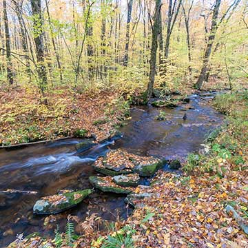
Over twenty-five miles of trails offer access to the best parts of the trust’s eleven accessible parcels, and on a recent hike with volunteer coordinator Brooke Loening, we meandered over the hundred-plus-acre ridgeline that constitutes most of the Goodody Preserve, situated almost on the border between Sharon, CT and Millerton, NY. The property is a prime example of today’s forests: a patchwork of several preserves that the SLT has acquired through a combination of private fundraising and public grants, both state and federal.
The stated goal of the trust is to acquire an additional 400 acres of open space by 2024, a goal that they can reach through a combination of easements, donations, and incentivized sales directly to the trust. Most of their holdings consist of land that would be difficult to develop or use for farmland, although much of it is former pastureland that has reverted to forest over the course of the last century. In my hikes on several of the properties, I noticed stone walls and relatively new-growth hardwood and hemlock forests that hint at their historical evolution.
A coordinated effort
Some of the properties are contiguous with working farms, too, and landowners such as the Wike Brothers have provided easements that facilitate public access to the trails on land where such access would be impossible or inconvenient. This allows trail networks to follow natural contours and to provide hiking experiences that are enjoyable without being excessively rigorous. It also results in interesting views that incorporate enclosed, wooded spaces with gracefully arcing fields.
Such coordinated efforts to acquire mixed-use land are not accidental, and neither is the pleasant path that Loening and I traversed in our two-hour hike through the Goodbody/Paley Preserve. As the volunteer coordinator, he works with stewart director Tim Hunter to design and execute trails that provide access to the best parts of each parcel while preserving the ecological integrity of the location. In some cases, this entails everything from routing a trail around an active hay field, grading a series of switchbacks that make a slope easier to climb, and constructing erosion bars that divert runoff from degrading a trail.
Making trails
The process of situating a trail begins with a survey of the terrain using maps and Google Earth to identify trail features and potential routes that avoid insuperable climbs and obstacles. In addition to easing public access, careful trail mapping will limit erosion on steep trails and the amount of construction and maintenance that can be achieved by volunteer trail stewards.
From there, Hunter and Loening assess the terrain in situ, spotting wildlife trails, natural switchbacks, and features that would support foot traffic. They use ribbons to mark the general location of the path and then flag the exact placement of the path itself. At that point, they can develop a list of tasks that require groundscaping by their team of volunteers.
That can include everything from clearing blowdowns and brush to building steps and erosion bars. The group maintains a spreadsheet of prioritized tasks, which Loening cross-references with his list of volunteers to organize work parties.
Not all volunteers are able to do all kinds of work – some are skilled with a chain saw, some are unable to lift heavy objects – but there are roles for any volunteer, and plenty of work to go around.
One small but brilliant decision Loening made was to limit work parties to two hours instead of the three or more that are often asked of volunteers. This reasonable commitment allows him to organize shorter, more frequent meetings that not only accomplish a lot of manual labor but build a sense of community and ownership among the volunteers. These trails are theirs, too, and they will use them and share them with others.
Their efforts add an element of appreciation for hikers who can notice not only the remarkable views and natural features, but the skill of the trail builders who make them accessible. For anyone who appreciates the opportunity to be present and attentive with their surroundings, their work provides yet one more feature to admire in our local area.
To learn more about the Sharon Land Trust and all that they do, call (860) 364-5137 or visit them online at www.sharonlandtrust.org.